Two stages contractable separately or together — from georeferenced 360° field video to the final dataset delivered to the client. Every record traceable at any time.
Comtacti's road inventory was designed for high contractual-demand environments — concessionaires with ANTT and ARTESP obligations, lenders such as BNDES and IFC, and public agencies with competitive tendering processes. Traceability is not an additional report: it is how the system works.
360° georeferenced video capture of the entire highway extent. The raw material for inventory — carried out by Comtacti or supplied by the client.
Classification and coding of all road elements from the 360° video, using the proprietary OMNI7 system. Each record linked to the source frame and coordinate.
Flexible contracting. Clients who already have their own georeferenced 360° or photographic survey can contract only the Asset Registration with OMNI7. Likewise, Comtacti can carry out only the DVS for clients who prefer to handle the classification in-house.
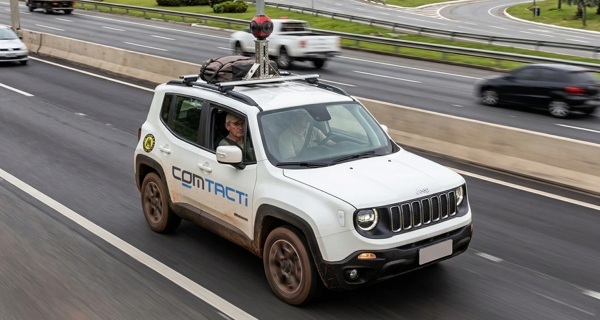
The DVS is the field stage: Comtacti's vehicle travels the full extent of the road filming in georeferenced 360° video, in both directions. The result is the raw material for asset registration, for iRAP road safety analyses and for any study requiring detailed road visibility.
Ladybug 30 MP camera
8,000 × 4,000 pixel resolution in 360° video. Captures the full lateral and vertical extent of the road — signage, assets, geometry and surroundings — in a single pass.
GPS PPP with < 2.5 m precision
Precision positioning system with embedded inertial unit to ensure continuity in tunnels up to 12 km without loss of georeferencing.
Real-time monitoring via OMNI7
Field routes are monitored in real time through the OMNI7 platform, enabling coverage gaps to be identified and rework triggered before the team leaves the area.
Filming in both directions
Increasing and decreasing directions covered in separate passes, ensuring full visibility of signage and assets on both sides of the road.
Equivalent terms found in tender documents
From the 360° video captured in Stage 1 — or supplied by the client — Comtacti's team classifies and codes all road elements directly in the OMNI7 platform. GPS is automatic: there is no manual coordinate entry. Each record is linked to the exact frame from which it was extracted.
Specialisation by attribute
Each technician codes up to 3 specialised attributes simultaneously — not all 78 at once. Specialisation reduces errors and increases classification speed.
Automatic GPS by frame
When an element is classified in the video, OMNI7 automatically links the GPS coordinate from the corresponding frame — no manual coordinate entry, no positioning error.
Real-time supervision
The supervisor monitors coding as it happens, correcting inconsistencies before they accumulate. Audit is not a final stage — it is a continuous process.
Automatic geometry calculation
Curvature and gradients are calculated automatically by the system from the GPS track — eliminating human variability in geometric attributes.
In a market where clients are regulated by ANTT, ARTESP and multilateral lenders, auditable data is not a differentiator — it is a contractual requirement. Comtacti brings this characteristic natively in the software, not as a manual review process.
Every inventory record is linked to the exact frame of the 360° video from which it was extracted. If the client contests any data, Comtacti presents the frame that proves the classification.
The system automatically records who classified each element, in which frame and at which time. The log is immutable and delivered to the client as part of the audit report.
The client can request reclassification or independent recount of any segment at any time, at no additional cost for discrepancies identified in a contractual audit.
iRAP (International Road Assessment Programme) is the global method for assessing the risk of death and serious injury on roads. The methodology codes dozens of attributes per segment and generates a Star Rating that enables comparison and prioritisation of safety interventions — required by BNDES and IFC in road concession projects.
Accredited organisation since 2018
OMNI7 system accredited for road surveys and road attribute coding. Active accreditation, renewed in 2022.
3 individually certified technicians
Senior members with individual Road Attribute Coding certification — ensuring operational redundancy on projects of any scale.
Native VIDA export
OMNI7 generates the VIDA CSV format directly from the registration — no rework. One field pass, two deliverables.
Multilateral lenders
BNDES and IFC require iRAP assessment in concession and highway financing processes with road safety impact.
Concessionaires and managers
Contracts with Star Rating improvement clauses — ARTESP, ANTT and DERs require initial and periodic assessment throughout the concession.
Engineering consulting firms
Road safety consultancies that need to subcontract iRAP coding to an accredited organisation.
Concessionaires, lenders and public agencies that rely on auditable data for contractual, regulatory and investment decisions.
Talk to a specialist. We can quote both stages together or just the registration, if you already have the survey done.